
Chiricahua National Monument – A Complete Travel Guide – Part 1
Traveling with Purpose is a reader-supported blog. In order to keep the lights on, I sometimes include links to products or services that I recommend. I may get commissions for any purchases that you make through those links, but it won’t cost you any more for the products. As an Amazon Associate, I also earn from qualifying purchases.
What’s so great about Chiricahua National Monument?
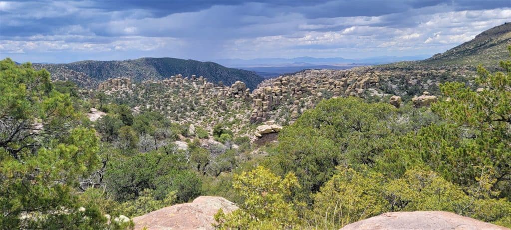
Chiricahua National Monument is a magical combination of a “Wonderland of Rocks”, a protected “International Dark Sky Park”, and over 12,000 acres [49 sq km] of nature and bird-watching paradise. You’ll find the gorgeous 8-mile tree-lined Bonita Canyon Scenic Drive and 17 miles of day-use hiking trails, a Visitor’s Center, campgrounds, picnic areas, and more. Because of its somewhat remote location, the park averaged only about 60,000 visitors per year (165 per day) before the pandemic even though admission is free.
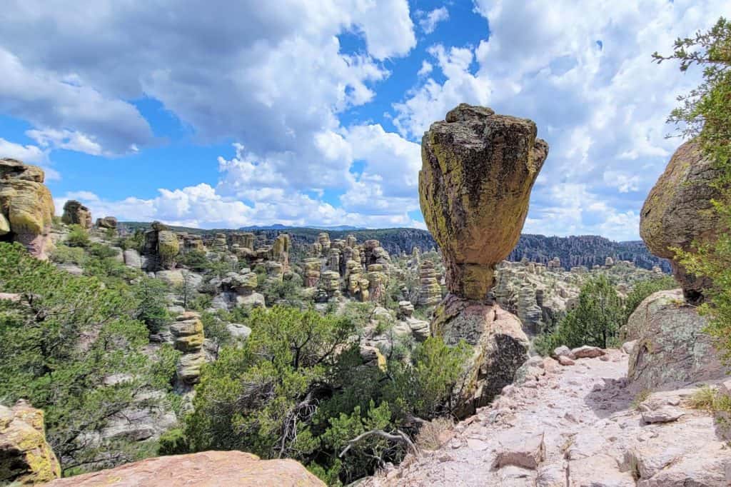
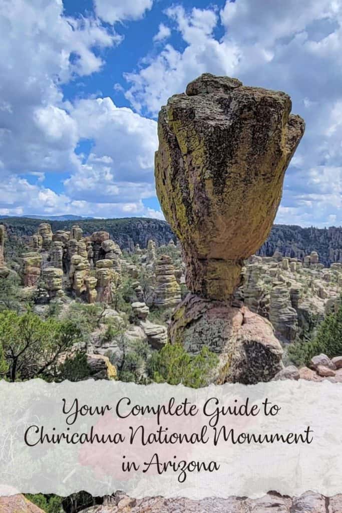
Personally, when I visited Chiricahua recently I was struck by the similarity of the amazing hoodoos and rock formations to Bryce Canyon National Park, but with a smaller footprint and slightly toned-down color palette. In fact, those who’ve seen Chiricahua are such big fans that the US Congress is considering [the Chiricahua National Park Act] to assign it the coveted designation as a United States National Park.
Where is Chiricahua National Monument?
Chiricahua National Monument is nestled in the Chiricahua Mountain range in the southeastern corner of Arizona, not far from the New Mexico state border and about 70 miles from the Mexican national border. The closest town with services is Willcox, Arizona, just 37 miles northwest. The metropolitan area of Tucson is about a 2-hour drive.
The monument is located in Cochise County, at the intersection of the Chihuahuan and Sonoran deserts, the southern Rocky Mountains, and the northern Sierra Madre.
See below for driving distances from nearby towns.
When was Chiricahua National Monument Established?
This region has been populated by humans as far back as 12,000 years ago. But in the mid-1800s, the Southeastern Arizona Territory was marked by 24 years of conflict and mistrust between US soldiers, Chief Cochise, and the indigenous Chiricahua “Apache” people in battles over land and the precious water needed to survive. You can read more about it on the national monument website here.
Early pioneer immigrant families were drawn by mining and ranching possibilities and settled in the Chiricahua Mountains, canyons, and valleys in the late 1880s. Beginning around 1917 members of the Erickson and Riggs families started Faraway Ranch, a guest ranch designed to share and promote the beauty of the area with tourists.
In 1923, Ed Riggs encouraged Arizona Governor George W.P. Hunt to visit Bonita Canyon and Faraway Ranch. After a spell-binding visit on horseback to the spectacular hoodoos, balancing rocks, and lush canyons he shared his experience with President Calvin Coolidge. In an effort to protect this unique environment, the President established Chiricahua National Monument on April 18, 1924, through his presidential authority under the Antiquities Act of 1906.
What Wildlife is Found at Chiricahua NM?
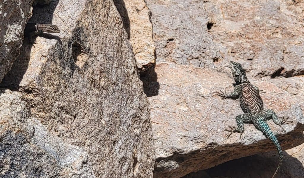
The nearly 2 million acres [7200 sq km] of Coronado National Forest surround Chiricahua Nat’l Mnmt, providing a vast land mass with very little disruption from humans. The variation in elevation of this sky island that rises quickly from the desert makes for a wide variety of habitats for wildlife as well. During our 2-day visit to the area, we saw several Coues white-tailed deer, a few Blacktail Jackrabbits, plus a plethora of lizards, bats, and birds. We were on the lookout for Black bears, Javelinas, Mountain Lions, and Coatimundi, but weren’t able to track any down.
If you watch closely you may catch a glimpse of some of the more unique insects in the area. You can find Arizona Sisters butterflies, Vinegaroons (whip scorpions), Walking Sticks, or Hercules Beetles within CNM. The most intimidating is probably the male Desert Tarantula. You may see one crossing the road or trail with his 4 to 6-inch leg span! These tarantulas are venomous, so don’t try to handle them. You can compare their bite to a bee sting.
Did you Know the Chiricahua Mountains are for Bird Lovers?
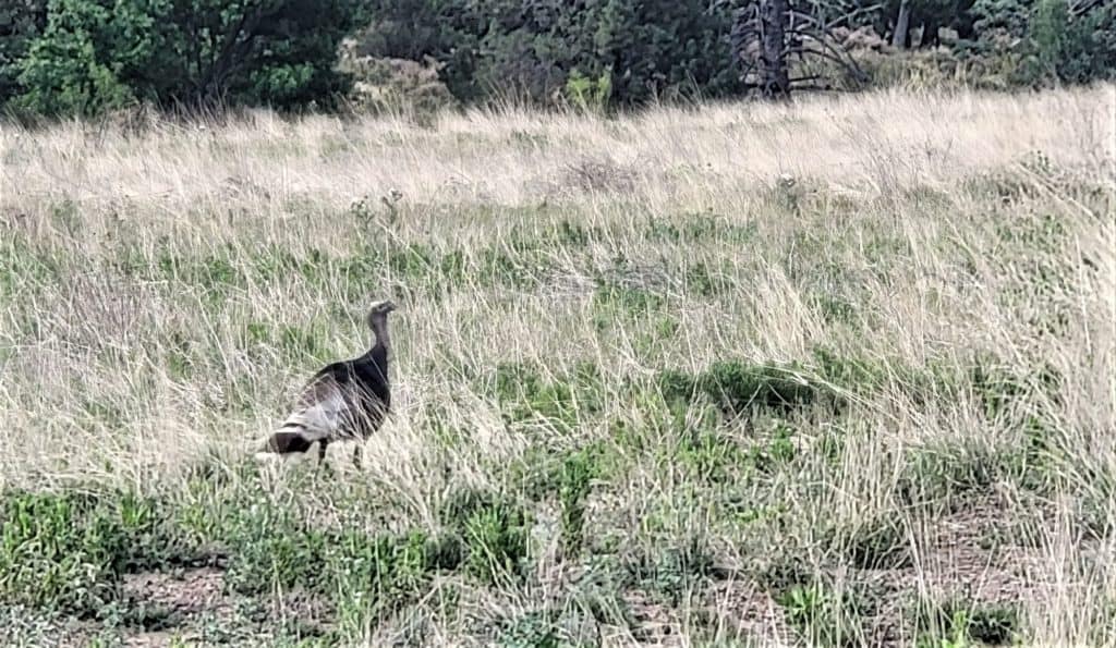
At least a dozen Gould’s wild turkeys wandered in the meadows just inside the park entrance. These large birds were hunted to near extinction in southeastern Arizona in the early 1900s. A partnership between several organizations and government entities moved 250 turkeys from Mexico to reintroduce them in this part of Arizona in the early 1980s. The program has been very successful.
Speaking of birds, Southeastern Arizona is renowned for its diversity of winged beauties. The “American Bird Conservancy” identified it as an “Important Bird Area”. Every January, during the Martin Luther King Jr. holiday weekend the nearby town of Willcox hosts the “Wings over Willcox Festival” to celebrate Cochise County and Chiricahua birdwatching. The long weekend is packed with field trips, seminars, and a nature expo. Topics aren’t limited to bird lovers either. The last festival included visits to local wineries, a working cattle ranch, and downtown historic walking tours.
Print out this Chiricahua Bird Checklist
If you’re an avid birdwatcher check out this Bird Checklist for Chiricahua National Monument. You can print it out and take it with you. The list contains the 100 most common birds that you’ll see. The list is also categorized by season. You’ll see if it’s there year-round or is migratory and only there in certain months. We were there in May and saw a (red-headed) Acorn Woodpecker, many blue and gray Mexican Jays, Gambel’s quail, Cardinals, Turkey vultures, and Roadrunners. The Visitor Center also keeps a running list of animal and bird citings in the park. And you can ask the rangers for the best places to spot your favorites.
What Kind of Hiking Trails are at Chiricahua Nat’l Mnmt?
Chiricahua NM has a wide variety of hiking trails that fit any fitness or experience level. Pick up a list of the hikes and descriptions at the Visitor Center. Ask the park rangers for recommendations based on what you’d like to see. If you like to take pictures and investigate up-close, as I do, be sure to add extra time to your hike estimation.
There are six hikes categorized as “easy”. These hikes are less than 1.2 miles [1.9 km] with little change in elevation. Some of these allow pets on a leash as well. The five “moderate” hikes take 1 to 4 hours with 500 feet [162 m] or less changes in elevation. If you’re looking for a “strenuous” hike there are three of those that take 3 to 8 hours with elevation changes from 500 to 1,000 feet [150 to 300 m].
While you’re on the trails remember that rock climbing on the pinnacles is prohibited for your own safety and the protection of the formations. Nearly all the hikes are dusty and have some areas where there’s loose rock or gravel, so be sure to wear appropriate shoes. It’s always important to pack a full bottle of water and maybe a snack too. You can fill up your water bottle at the Visitor Center.
Where is the Best Place to Start at Chiricahua?
Start at the Chiricahua Visitor Center and talk to the park rangers about what’s going on while you’re there. You may get to attend an evening campfire talk at the amphitheater or go on a ranger-led hike. They’ll help you choose the best trails or picnic areas and give you updates on any weather issues to prepare for. Get your National Parks Passport stamp and pick up a few souvenirs, books, or t-shirts while you’re there too.
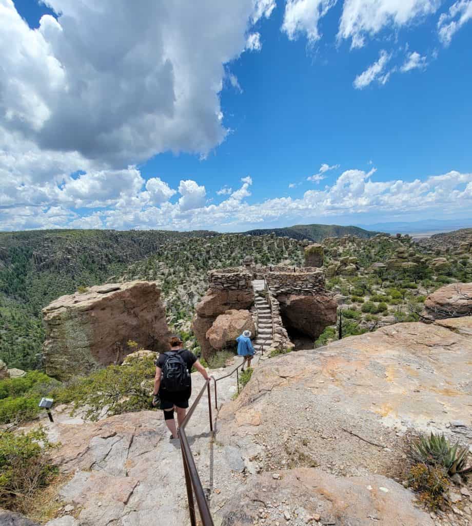
After the Visitor Center, we followed the scenic drive to Massai Point Nature Trail. No pets are allowed on this trail. This easy hike is only a half mile [0.8 km] but is at an elevation of 6,870 ft [2,094 m]. It’s the perfect hike to get an overview of the area and read about the natural history along the way. Part of the trail is also wheelchair accessible. If you’re visiting during monsoon season in the summer, it’s also the perfect spot to see the storms roll in each afternoon.
A wonderful option in winter or spring is to catch the free shuttle from the “Faraway Ranch” parking lot. It leaves at 9:00 am or the Bonita Canyon Campground at 9:10 am. There’s limited seating, so reserve your spot either the day before or earlier that morning at the Visitor Center. The shuttle will drop you off at the Echo Canyon or Massai Point trailheads. This allows you to hike one way back to the Visitor Center or where you parked.
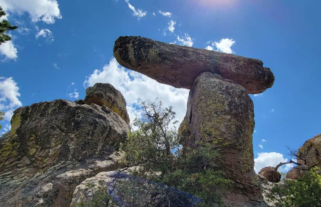
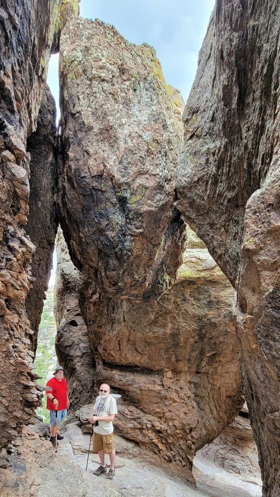
Where can I see the Cool Balancing Rock Formations at Chiricahua?
Talk to a park ranger to get the best tips on which hikes fit within your timeframe, fitness level, and interests. We chose the first mile or so of the Echo Canyon Trail and hiked just past the rock formation called “The Grottoes”. [see photo below] The hike gave us a chance to immerse ourselves in the hoodoos and amazing rock pinnacles. The full Echo Canyon Loop trail takes about 2 to 3 hours and has some wooded areas. Most people prefer to hike it counter-clockwise because of the elevation changes.
You can also find more information about hiking trails in the vast surrounding Chiricahua Wilderness and Coronado National Forest by visiting the U.S. Forest Service website here.
Pick up this extensive map of the Chiricahua Mountains from Green Trails for hiking, backpacking, horseback riding, biking, or birding in the area. It includes the national monument and Fort Bowie National Historic Site as well.

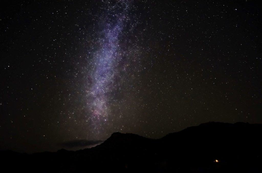
Is Chiricahua Nat’l Mnmt a Good Place for Star-gazing?
Yes! If you’ve been to Arizona you’ll quickly see that we have expansive amounts of open space and clear skies in many parts of our great state. Southern Arizona also boasts nearly 300 days of clear skies each year.
Chiricahua NM was designated as one of Arizona’s 12 “International Dark Sky Parks” in 2021. These parks are defined as lands with “exceptional quality of starry nights and a nocturnal environment that is specifically protected for its scientific, natural, educational, cultural heritage, and/or public enjoyment.”
At various times throughout the year CNM partners with the Tucson Amateur Astronomy Association (TAAA) to host Night Sky Parties. This gives visitors a chance to peek at the stars through a telescope and learn more about stars and planets. The TAAA also offers other stargazing adventures nearby if the park isn’t hosting anything when you’re there. You can find out more about TAAA at their website here.
Are you hoping to bring a telescope or binoculars for star-gazing or your camera for astrophotography? Check the forecast and other details at this website, “Clear Outside“.
When is the Best Time to go to Chiricahua National Monument?
The elevation of Chiricahua National Monument varies from 5,124 feet [1,562 meters] at the entrance to 7,310 feet [2,228m] at the summit of Sugarloaf Mountain. This wonderful diversity means that all four seasons happen in the park.
The best months for hiking are in spring and fall. Average high temperatures run from the mid-60s F to low 80s and lows are in the mid-30s to mid-40s at the Visitor Center. Record highs of over 100 degrees F [37.7 C] have happened from May to September, but June is usually the hottest month of the year.
Prepare for Summer Monsoons and Winter Snow
Be prepared for frequent afternoon monsoon rains from June to September when the majority of rain falls for the year. These storms can move in quickly. They bring thunder, lightning, strong winds, and even dangerous flash floods, so always check with a park ranger before heading out for a hike or setting up camp. They can let you know what’s in the forecast and how to prepare for any severe weather.
Snow is possible from late fall through early spring, and may bring up to a foot at a time. This can make rocks slippery and hiking dangerous. The snow won’t stay long though, except in shaded areas. The most snow falls in December and January.
Your complete guide to Chiricahua National Monument is continued in Part 2 here.
Find out critical info to know before you go, including food service, lodging, camping, pets, and more to do nearby. And you can see distances to nearby towns and landmarks for your road trip plans.
Have you been to Chiricahua NM? What was your favorite part or what would draw you to go there? I’d love to see your comments below.
Category: Arizona, Camping, Places to Eat & Drink, Places to Stay, Southwest States, United States
Subscribe
If you enjoyed this article, subscribe to receive more just like it.


I did not know much about Chiricahua National Monument but now I’m adding it to my bucket list. Looks like a beautiful area to visit.
It really is a true hidden gem in Arizona. Enjoy your visit in the future!
Ahh, dark sky parks are the bestt!! Visiting all the national parks is on my bucket list, but it’d be awesome to check out more of the national monuments as well! Thanks for sharing nearby places to check out too! I tend to like packing a billion things into my itinerary whenever possible!
Even though this seems like a remote area that most people don’t know about, there are tons of things to do. And, if you love dark sky parks and cities, Arizona is full of them. You may also want to check out nearby Mt. Lemmon (near Tucson) and the Sky Center Observatory. https://skycenter.arizona.edu/ We’re going there in June.